 |
| Did a false glide slope lead TK6491 astray? Never have heard of this before. |
My profound sorrow for those lost, injured, and mourning.
This blog is not trying to determine why this accident occurred.
These observations stem from sparse ADS-B reports plus other references not known to be accurate combined with best-intentioned judgements and helpful advice from online commentators.
The lengthy discussion reflected in this blog is a tool to understand the relevance and benefit of ADS-B data as a tool for safety investigation.
This is not a safety investigation of TK6491. The official safety investigation will conclusively resolve any uncertainties.
The official investigation has access to much more information and expertise pertinent to this accident than me.
This is not a safety investigation of TK6491. The official safety investigation will conclusively resolve any uncertainties.
The official investigation has access to much more information and expertise pertinent to this accident than me.
From MAK:
Technical investigation of the accident is being conducted by the IAC Investigation team with participation of the Kyrgyz Republic representatives on the basis of the Interstate Agreement on Civil Aviation and Use of Airspace where the Kyrgyz Republic is one of the Contracting states. The Investigation Team has started its work.
Representatives of Turkey as the State of the Operator and State of Registry and also the USA as the State of Design and Manufacture of the aircraft and engines are participating in the investigation team work in accordance with Annex 13 to Convention on International Civil Aviation (ICAO).
The investigation team is working in close collaboration with the Government commission of the Kyrgyz Republic as to mitigation of consequences and provision of assistance to the families of victims.

 |
| http://www.inform.kz/en/it-will-take-6-months-to-establish-causes-of-747-crash-near-bishkek-expert_a2992455 |
Please take note that other explanations or factors not known or misunderstood herein may correctly determine different conclusions - in other words, the conclusions herein may be wrong.
The theory that a glide slope signal was transmitted in a manner as depicted has no basis in reference literature, and would never be sanctioned as a serviceable system. I don't know if a back-course glide slope signal would be useful from runway 08 glide slope. I cannot explain why the false glide slope intercepted so far beyond runway 08.
Please take the False Glide Slope theory as a convenient way to explain the data where no other explanation makes better sense; there can be no conclusive proof based on the ADS-B data alone. The FDR data will reveal the glide slope deviations and what guidance was being used in this tragedy. Only then can we conclusively relate the ADS-B data to other aspects.
Nothing herein explains why the FAP was not followed, why the marker beacons were apparently ignored, why the moving map on the navigation display was not compelling, and why the airplane descended too low for any published procedure.
"Why" aspects are not in scope of ADS-B data, nor is any insight into actual flight deck controls or airplane serviceability. The reader should refer to the formal MAK investigation for understanding those aspects and any others.
1) TK6491 approach appears to be established significantly displaced from any approved procedure for runway 26. The localizer capture traces precisely the same path as a prior flight, suggesting that the reported position was accurate. ADS-B position data also matched prior airport surface operations.
The flight profile appears to have missed capturing the runway 26 glide slope by flying too high (from above) and following a false glide slope, never descending to the glide slope intercept altitude of 3,400 feet.
The airplane appears to capture some form of false glide slope.
The flight profile appears to have missed capturing the runway 26 glide slope by flying too high (from above) and following a false glide slope, never descending to the glide slope intercept altitude of 3,400 feet.
The airplane appears to capture some form of false glide slope.
2) TK6491 continued to descend below minimum approach altitude for every approved procedure.
TK6491 starts to descend on the false glide slope. The airplane dips below the false glide slope when in proximity of ILS26 glide slope, then recaptures the false glide slope and follows it to the point of impact.
It is noted that the glide slope frequency for runway 08 and runway 26 are the same, and the the localizer for runway 26 provides IDENT.
The data trail is aligned roughly with a back-course glide slope based on runway 08, but terminates far off the runway.
There has been no statement whether runway 08 glide slope was operating at the time of the accident.
There is nothing available to conclusively show what TK6491 was using for descent reference.
In any case, TK6491 overflew the ILS26 Outer and Middle markers well above expected altitude, may have overflown ILS08 markers in reverse (unsure if turned-on), proceeded below any approach minima, and apparently completely disregarded the navigation display moving map.
3) TK6491 missed approach appears to be too late to prevent controlled flight into terrain (CFIT).
The aircraft came to rest nearly below the missed approach points last recorded.
With an overlay of the ADS-B data and a published crash zone survey, the point of impact appears to begin directly underneath the last ADS-B data point.
The ADS-B baro altitude data suggests an abrupt climb that is not conceivable. The vertical speed information suggests no more than 20 feet was gained.
It seems more likely the ADS-B baro altitude static port or otherwise was corrupted, that this was a case of controlled flight into terrain (CFIT).
4) The Flight Data Recorder (FDR) will offer answers, from which the ADS-B data can be re-evaluated for accuracy and utility under these circumstances.
Flight Path
The following Google Earth plots show TK6491 final approach ADS-B data points from different angles. Accurate position reporting has been confirmed by examining this an earlier flights on this airplane. The altitude is adjusted 300 feet above the reported pressure (baro) altitude to account for high ambient pressure.

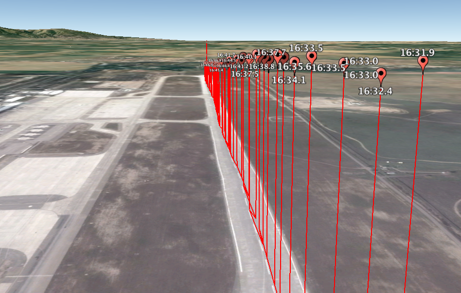


<note, I earlier posted this composite with the crash site upside down. Sorry for any misunderstanding. This orientation is much more sensible given the trajectory of the airplane.>


Location: UCFM
Day of month: 16
Time: 01:00 UTC
Wind: Variable in direction, Speed: 1 m/s
Visibility: 50 m
Runway 26, touchdown zone visual range is
Weather: Freezing (or super-cooled) Fog
Sky is obscured -- vertical visibility: 100 feet
Temperature: -09 degrees Celsius
Dewpoint: -10 degrees Celsius
QNH (Sea-level pressure): 1023 mb (30.21 in Hg)
No significant changes expected in the near future
Pressure altitude (29.92 altitude) or uncorrected Barometric altitude, requires an adjustment to reflect mean sea level (MSL). The high pressure (0.3 in Hg) above standard would require an addition of about 300 feet to the pressure altitude. This correction is plus/minus at least 50 feet.
 |
| http://www.dauntless-soft.com/products/Freebies/TrueAirspeedCalculator/ |
 |
| from flightradar24.com |
Decision to Go-Around
flightradar24.com provided data showing that the airplane appears to have attempted a missed approach (go-around).
The missed approach appears to have been initiated at about 01:17:15 with the last report at point of impact less than two seconds later. The airplane was about 16,000 feet past runway 26 threshold - beyond the end of the runway. The impact was not much further.
The plane traveled over 40 seconds from when TK6491 had passed more than 4,000 feet from runway 26 threshold to the point where the descent was abandoned and a missed approach commenced.
The minimum pressure altitude was reported at 1,800 feet. With correction, this would reflect 2,100 feet. 2,100 is about 11 feet above the Runway 08 (other end of runway 26). Noting that this correction and the reported pressure altitude has some tolerance, it would appear the Missed Approach commenced upon close proximity to the ground (and well beyond the runway).
Visibility was 50m.
There were no real winds to encounter.
Density altitude was 800 feet below sea level, enhancing airplane performance.
Each instrument approach as a point where the flight crew must make a decision based on having the runway in sight, or failing that, to miss the approach.
Bishkek/Manas Charts
747-400 operates in approach speed category D.


The ILS 26 glide slope has a sequence of expected altitudes for monitoring the approach.
IMN DME (runway 08) is out of service, but would not be in use for this approach. Instead MNS DME would be operational.
A table (in km) is provided.
LOM BK 2800' (DME MNS 2.5 km) TK6491---> 3400' (600' high)
LMM B 2290' (DME MNS ~0.5 km PAST) TK6491---> 3300' (1000' high)
In summary, minima by approach:
ILS Cat II 2142'
ILS Cat 1 2221'
2 NDB 2391'
VOR/DME 2418'
In all cases, the missed approach would be expected prior to over-flying runway 26. TK6491 flew the length of runway 26 and beyond before commencing the missed approach. The altitude was 300 feet below any non-precision approach. The altitude would be expected for a Cat II approach, but there is no rational explanation for how the glide slope could have been so far astray.
Some form of RNAV approach could be crafted that would describe the controlled descent into the wrong location, but underlying moving map presentation would reveal the gross navigation error. Unless the gross navigation error reflected aircraft position. The presence of GNSS and radio nav aids is difficult to reconcile with any aircraft position offset theory.
Shared ILS Frequency - False Glide Slope?
The ILS for runway 08 and runway 26 share the same frequencyLocalizer 111.7 MHz
Glide Slope 333.5 MHz


Runway 08 ILS has an outer marker "MN" and middle marker "M".
Runway 26 ILS has an outer marker "BK" and middle marker "B".
Runway 08 Localizer Ident is "IMN"
Runway 26 Localizer Ident is "IBK"


Procedurally, only one ILS approach is active at a given time. The non-active Localizer and Glide Slope radios would be turned off.
Localizer and Glide Slope radios transmit a carrier frequency with two mixed modulations of 90 and 150 Hz. The deviation indicator shows left/right or up/down based on the ratio of the two signals.
A localizer flown "back-course" offers reverse deviations.
A glide slope is not normally flown back-course. The presence of a valid glide slope signal in back-course approaches is known and procedurally should be disregarded (when flying a back-course localizer approach).
The IDENT for an ILS is based on the Localizer frequency.
One scenario is that the runway 08 glide slope was turned on while the ILS on runway 26 was active. This is just a guess - there has been no such report.
With only one localizer, the IDENT would match runway 26 "IBK".
The markers were flown on both ends of the runway. The would have been encountered in this order:
BK B M MN
Is it possible that TK6491 captured a false glide slope for runway 08 while tracking the localizer for Runway 26?
The following plots show TK6491 (red) and TK6489 (green) against a projection of the runway 26 glide slope (blue). A false glide slope (yellow) is projected from the point TK6489 arrested it's descent. TK6489 was flown on the same route, by the same airplane, three days earlier.
TK6489 captured the glide slope for runway 26 from below, and proceeded to land normally.
TK6491 was flying well above the runway 26 glide slope. It appears TK6491 captured the false glide slope, preventing it from descending low enough to capture ILS26 glide slope.


The localizer capture is identical with TK6489.


As TK6491 descends along the false glide slope, it strays below when nearing the ILS26 glide slope. this may be because the deviation from the 150 Hz component from the false glide slope was mixing with the 90 Hz component from ILS26 glide slope. As TK6491 flies closer to ILS26 glide slope, the influence drives TK6491 towards it, seemingly almost half-way. As TK6491 proceeds, the influence from ILS26 is lost and TK6491 flies up to the false glide slope.
Is it possible that the two glide slope signals were mixing and briefly ILS26 shifted the deviations its way?


TK6491 proceeded to stabilize about 2500 feet MSL and then apparently recaptured the false glide slope roughly aligned with runway 08, following to the point of impact. The stable portion is where the influence of the false glide slope and ILS26 glide slope were fairly constant. Once TK6491 flew nearer to the airport, ILS26 influence waned, and the airplane was directed back up to the false glide slope.


Was this a back-course reflection of runway 08 glide slope (which should not have been operating)?
 |
| TK6489 descended where TK6491 seems to have leveled off - leading to both flights capturing apparently different glide slopes |


The localizer capture is identical with TK6489.


TK6489 intercepts the glide slope at 3400 feet, at the Final Approach Point. TK6491 is well above the FAP, biased presumably where the 150 Hz of the false glide slope is balanced with the 90 Hz from ILS26 glide slope.

Is it possible that the two glide slope signals were mixing and briefly ILS26 shifted the deviations its way?


TK6491 proceeded to stabilize about 2500 feet MSL and then apparently recaptured the false glide slope roughly aligned with runway 08, following to the point of impact. The stable portion is where the influence of the false glide slope and ILS26 glide slope were fairly constant. Once TK6491 flew nearer to the airport, ILS26 influence waned, and the airplane was directed back up to the false glide slope.


Was this a back-course reflection of runway 08 glide slope (which should not have been operating)?
The presence of overlapping glide slope signals is not ever intended to occur, and thus strays from any reference literature.
Normally, false glide slope refers to artifacts of the intended signal that reside in multiples of three degrees (six, nine) along the intended glide slope. Normally, a false glide slope would cause a steep approach to runway 26, or possibly reversed deviations. There is no false glide slope from runway 26 that would explain the profile TK6491 flew.
The only explanation for the navigation is somehow the runway 08 glide slope was transmitting, somehow the back course signal was usable. I cannot attest to this other than that the data suggests something drew TK6491 away from the intended glide slope. Note that the glide slope radio is tuned by the LOC frequency (paired), and the fact that runway 08 glide slope is built to operate on the same frequency as runway 26 fuels suspicions.
Was it a map shift? Not based on the localizer capture, which was exactly the same as three days earlier.
Was it some form of VNAV procedure? Not as flown, there would be no upset, it would be stable.
Was it some form of false signal from ILS26? There is no guidance from that end of the runway that would offer a usable signal to match the false glide slope.
Was it Vertical Speed Mode? Based on what guidance?
I can explain TK6491 if the false glide slope were 333.5 MHz, and that it would blend with ILS26 glide slope on 333.5 MHz in a manner that is shown. Every other approach procedure that is setup (designed) along the false glide slope path would have not resulted in the upset where it appears ILS26 glide slope pulled it down a bit from the false glide slope. It the approach path was stable, then other modes (VNAV, vertical speed) seem possible.
Go-Around Airspeed and AltitudeNormally, false glide slope refers to artifacts of the intended signal that reside in multiples of three degrees (six, nine) along the intended glide slope. Normally, a false glide slope would cause a steep approach to runway 26, or possibly reversed deviations. There is no false glide slope from runway 26 that would explain the profile TK6491 flew.
The only explanation for the navigation is somehow the runway 08 glide slope was transmitting, somehow the back course signal was usable. I cannot attest to this other than that the data suggests something drew TK6491 away from the intended glide slope. Note that the glide slope radio is tuned by the LOC frequency (paired), and the fact that runway 08 glide slope is built to operate on the same frequency as runway 26 fuels suspicions.
Was it a map shift? Not based on the localizer capture, which was exactly the same as three days earlier.
Was it some form of VNAV procedure? Not as flown, there would be no upset, it would be stable.
Was it some form of false signal from ILS26? There is no guidance from that end of the runway that would offer a usable signal to match the false glide slope.
Was it Vertical Speed Mode? Based on what guidance?
I can explain TK6491 if the false glide slope were 333.5 MHz, and that it would blend with ILS26 glide slope on 333.5 MHz in a manner that is shown. Every other approach procedure that is setup (designed) along the false glide slope path would have not resulted in the upset where it appears ILS26 glide slope pulled it down a bit from the false glide slope. It the approach path was stable, then other modes (VNAV, vertical speed) seem possible.
ADS-B vertical speed was stable between 700-900 fpm descent.
At 15 seconds V/S shifted to -320 fpm. This would be the point of go-around.
At 16 seconds, V/S shifted to +1152 fpm. This was the last reported vertical speed. For the duration of one second, this vertical rate would integrate to about 20 feet climb.
ADS-B reports show that the airplane begins to climb and airspeed initially rises, but begins to drop just when the data reports stop prior to the impact.
The airspeed rise following a very stable approach would suggest power might have been applied to initiate the go-around.
The steep climb portrayed by the ADS-B final two altitude data points suggest that the airplane might have been over-rotated, leading into a stall condition, without room to recover.
There is no ADS-B position data leading directly to the impact if the altitude reports are accurate.
What if the baro altitude static pressure source was corrupted when the aircraft impacted while the last two reports were being transmitted?
A sharp pitch up to cause the TK6491 to zoom 500 feet up in just over a second (and translating just over 300 feet) is inconceivable.
A 747-400 airplane conceivably could be rapidly pitched up if
1) full nose up elevator applied
2) nose up stabilizer trim applied
3) aft CG shift due to cargo breaking loose
4) improper spoiler deployment
5) rapid ice accretion
Note that if somehow the crew coupled a multi-channel approach, that the autopilot purposely mistrims the stabilizer to minimize nose-down authority (the flare spring) that causes a pitch up moment if the autopilot is disconnected.
Note that application of go-around power from approach power settings will cause a pitch up moment.
The flight maneuver to connect the dots is so severe that it is still hard to accept.
If the ADS-B baro altitude reports were erroneous as a result of the crash itself, then the aircraft position data is understandable in relation to the crash survey.
If the impact was controlled flight into terrain (CFIT), then the altitude data is corrupted by the crash itself.
If the impact is a result of loss of control (LOC), where the airplane pitched up violently, climbed, and slid back down, then the altitude data is correct. I do not believe this scenario is likely.
The CFIT is much more understandable.
The ADS-B altitude data suggests LOC. The ADS-B Vertical Speed and position data suggest CFIT. I think the altitude data was corrupted in the crash.
Thanks to reader "bc" for helping overlay the crash zone and for suggesting the CFIT scenario. I agree.
The FDR data will offer a conclusive depiction, from which this situation may be better understood.


Accuracy of Reported Position
The approach appears to be centered on the runway, but the descent profile and missed approach point is not where one would have expected it. Examining prior reports from this particular aircraft show a high precision in reported position.
 |
| TK6491 departure from Hong Kong-alignment and takeoff speeds are accurate |
 |
| TK6489 Hong Kong (13 Jan) -alignment and takeoff speeds are accurate |
 |
| TK6489 Bishkek - 13 Jan -alignment and landing speeds are accurate |
 |
| Flightradar24.com may have not synchronized blending data from more than one receiver. The offset appears to be less than one second, and does not materially change the information presented. |
Stay tuned!
Peter Lemme
peter @ satcom.guru
Follow me on twitter: @Satcom_Guru
Copyright 2017 satcom.guru All Rights Reserved
Peter Lemme has been a leader in avionics engineering for 35 years. He offers independent consulting services largely focused on avionics and L, Ku, and Ka band satellite communications to aircraft. Peter chairs the SAE-ITC AEEC Ku/Ka-band satcom subcommittee developing PP848, ARINC 791, and PP792 standards and characteristics.
Peter was Boeing avionics supervisor for 767 and 747-400 data link recording, data link reporting, and satellite communications. He was an FAA designated engineering representative (DER) for ACARS, satellite communications, DFDAU, DFDR, ACMS and printers. Peter was lead engineer for Thrust Management System (757, 767, 747-400), also supervisor for satellite communications for 777, and was manager of terminal-area projects (GLS, MLS, enhanced vision).
An instrument-rated private pilot, single engine land and sea, Peter has enjoyed perspectives from both operating and designing airplanes. Hundreds of hours of flight test analysis and thousands of hours in simulators have given him an appreciation for the many aspects that drive aviation; whether tandem complexity, policy, human, or technical; and the difficulties and challenges to achieving success.
An instrument-rated private pilot, single engine land and sea, Peter has enjoyed perspectives from both operating and designing airplanes. Hundreds of hours of flight test analysis and thousands of hours in simulators have given him an appreciation for the many aspects that drive aviation; whether tandem complexity, policy, human, or technical; and the difficulties and challenges to achieving success.
Physically, it is not possible for an aircraft to gain 500 ft in 1 second when the aircraft is in descent the second before, unless rockets were attached to the aircraft and suddenly ignited at the perigee. Even then those would have to be very powerful rockets. Thus something seems off.
ReplyDeleteHi Michael,
DeleteI am mystified as much as you! In my head I see a hammerhead stall leading to a tail slide, all in the soup.
I think it would be possible to pitch up the airplane violently in less than two seconds if full elevator, maybe runaway stab, or shifting cargo. Plus go-aroiund power application pitches you up. There is a "flare spring" to protect against nose down handover (deliberate stab mis-trim), but I think only for triple-channel coupled approach.
I honestly have no idea what happened. The data does not reveal enough information. The FDR will offer significantly more insight. For now, it is idle speculation, wonderment, and profound sorrow.
What beam were they flying is the first question. The second is the missed approach. Note, the two data points in the go-around have similar climb rate.
Peter
This accident is hard to fathom. At 100 ft AGL, would they have been able to see the runway, most of it was behind them?
ReplyDeleteIt appears that if they did see ground, they believed they were still before the threshold and trusted that the numbers were about to appear. I'll predict that the last words before impact if any were an expression of complete surprise.
Hi bc,
DeleteI cannot reconcile their view out the foggy windscreen Versus the Navigation Display that would have showed considerable overflight from runway 26 threshold. Could they have been so fixated searching for the runway lights to have ignored the primary navigation instruments for over 30 seconds?
I cannot fathom what procedure this crew were utilizing to arrive on this profile.
I cannot fathom why they descended below every altitude demanding they miss the approach.
Was there complete loss of situational awareness? Were the instruments not correct?
It is not my place dwell on the human aspects or the terror, rather I express profound sorrow for those lost and their loved ones.
The missed approach profile is so abrupt, and the wreckage so proximate, that the flight maneuver cannot be anything normal. The FDR will offer insight into what the control inputs and surface positions were through the last stages.
Thanks,
Peter
I created an image showing impact point consistent with ground damage.
ReplyDeletehttps://c1.staticflickr.com/1/543/32251458862_e92544a3e1_z.jpg
Hi Peter,
ReplyDeleteIn the composite of map and crash damage I believe you have one of the images in the wrong orientation. I created a composite with the correct orientation. https://c1.staticflickr.com/1/727/31575944154_8e9f835dc1_h.jpg
You can see that the crash damage is just to the north side of the extended centerline and starts below the last data points recorded. I believe the last two data points may have correct coordinates, but the reported altitude is incorrect because the airframe was breaking apart at those points.
FZ981 (FlyDubai accident Rostov-on-Don) shows a more typical loss of control (LOC) during Go Around (GA), and you can see the ADS-B data is quite different in this case.
Apart from the last two reported altitudes, the ADS-B track and ground damage are consistent with CFIT rather than LOC. I know that seems incredible, but I believe the FDR will confirm it.
Regards
Hi bc,
DeleteMany thanks for the correction. I had reviewed the "drone" film to better understand the orientation and must have gotten confused. I updated it as you suggest, and agree the alignment is much more understandable.
I share your skepticism, while trying to remain faithful to the data. This will be a learning experience once the FDR data is released. Peter
Hi Peter,
ReplyDeleteIt does look like they captured a false glide scope, or believed they were on a valid glide slope, or were attempting autoland (no DH)?
In each case, it appears to indicate an over-reliance on automation and/or failure to monitor properly, which seem to be characteristics of several recent accidents. I will leave speculation as to causes to the experts.
I hope the official reports will shed more light and reveal any lessons to further improve safety.
Regards
Hi everyone.
ReplyDeleteI am Turkish aircraft technician who worked in Act airlines for three years. I have a lot of friend in Act. One of them Ihsan Koca died in accident. Rip (Allah rahmet eylesin) ihsan koca. It is very clear aircarft follow false glide path, in this visbility pilot only have glide slope signal whatever use autopilot or manuel. As we see graph photo which shows normal path and false path, aircraft try to follow false glide path as a normal landing.
On the other hand why pilot cant decied go around on time.
Akin
The false glideslope comes from the side-lobe of the same GS transmitter, Ergo, the false glideslope is much steeper like 7-9 degrees, and track to the same threshold, not to the other side,. The 747-400 cannot follow this. There was something else, however the work what Peter did, is perfect. The aircraft was high, was un-stabilzed, and the crew did not utilized the signs of the technically impossble, legally questionable approach. They followed something, which is absolutely far away from any LowVis procedure.
ReplyDeleteSolutions are:
-Discontinue the approach well before /not? GoAround
-Being at 3400' landing config at FAP /not? Go Around
-Having dual/ triple CH AP on and LAND3/LAND2 not? GoAround
-Being correct alt over OM /not? Underground
- at DH do a proper GA
Peter, any idea why your comment (referring to this post) has been deleted (censored?) from avherald site?
ReplyDeleteavherald.com and pprune.org have both expressed concerns that the FR24 data cannot be trusted, and therefore they object to any analysis based purely on the FR24 data set. I am working with avherald off-line to understand their concerns and will follow up with flightradar24.com for response.
DeleteNote that one post was struck for having embedded a link to this blog (spelled out).
I am frustrated for their decision, and for the absence the welcome feedback their boards brought forth.
It is true that FR24 reports in other cases have had positions based on IRS, leading to position uncertainty. We are seeing some issues in this case with baro altitude. We have evidence of some sync. issues blending receiver report timestamps.
I do not believe fr24 is manipulating the data set in some devious manner. the gaps between reports leaves a lot to be filled in. In any case, the scrutiny is worthwhile so we can best characterize the information.
From PPRuNe:
DeletePPRuNe Towers
Dep Chief PPRuNe Pilot
Join Date: Jan 1997
Location: UK
Posts: 6,280
A very simple judgement,
No real news for several days.
Working pilots have abandoned the thread
It is totally overwhelmed by armchair and desk bound accident fiends
All discussion became endless posturing over nonsensical and simply wrong ADSB data points
The wrong data is assigned greater importance than the actual crash tracks and visuals because our accident boffins find data more convincing while these boffinistas tunnel in on patently wrong numbers.
Zero legal threats and zero contact from the ostensible "owners."
Therefore thread killed until there is real news from the initial formal report and the data recorders and the pilots can step in again
Rob
I see. At least PPRuNe gave an explanation, avherald just deleted your post and follow-ups...
DeleteAnyway, thank you for the information, and for your passionate work.
Yeah, I've been wondering too, even tried to ask Simon, to explain reasons of deletion, as this is as much "qualified speculation" as many others there, kept in thread, but my question got just "redacted out" either in few minustes... :)
DeleteI never ever heard of a "false Glide Slope" signal parallel to the correct signal. Yes I know and have experienced (oops) side lobe G/S signals, but 1st they lead to the same touch down point, 2nd give a very high ROD so that even well below average pilot will find out something doesn't fit. Maybe TK-6491 was on VNAV or V/S?
ReplyDeleteHi Heinz,
DeleteThis strays into an area not covered by any literature I can find. You are correct in describing front-course false glide slope. These are encountered at multiples of 3 degrees (the primary glide slope angle). The even multiples have reversed deviations, to make them most interesting. All the front course glide slopes terminate at the same point - airplanes would be directed to the same point in all cases.
Back course glide slope is the issue in question. This would be encountered in a back course localizer approach. But in this case, the back course glide slope would lead you to the end of the runway, and not useful. Pilot training warns that a back course glide slope may appear valid, but should be ignored (since it will lead you to the wrong end of the runway).
In this case, it appears that a back course glide slope from the runway 08 ILS was generated, and that it was a valid signal for TK6491 to follow. The influence of the glide slope from runway 26, on the same carrier frequency, explains TK6491 dip when tracking inbound. I have no idea if this back course glide slope from runway 08 (the false glide slope) would produce a navigable signal, nor can I explain why it would have let TK6491 so far past the runway 08 threshold, unless the signal was somehow reflected from the front course 08 signal, not directly a backwards radiation. As I mentioned, I don't have any experience or reference to judge the back course signal features.
I hope MAK releases data soon to confirm. They have just mentioned that the aircraft systems were operable, and that they were looking into the landing system. Again, the issue is someone may have turned on the runway 08 glide slope in error while runway 26 glide slope was in use.
TK6491 approach proceeded below Cat II ILS minima, and overflew the FAP, LOM, and LMM well above acceptable altitudes. Any procedure would navigate in a stable descent to the minimum altitude. No procedure would purposely include a dip in the flight path on final. That dip would also violate stable descent procedures. The only guidance I think that would lead the airplane through such an excursion is glide slope. And no glide slope has a dip in it. But in this case, if two glide slope signals blended, then TK6491 would dip exactly as shown. Peter
DeleteAfter reading the preliminary report as of Mar 24th, your presentation of ADS-B data looks very accurate. Thx and keep up your good work.
ReplyDelete